|
|---|
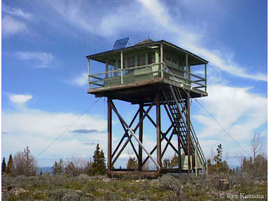
| BLACK BUTTE LOOKOUT | |
|---|---|
Developed in 1933 with a 20' pole L-4 tower, there was also a patrol point 1/2 mile east. The original pole tower legs were replaced with treated timber legs later on. The concrete piers were redone in 1994. Used during emergencies for a number of years, the tower is presently deemed unsafe to occupy. |
|
| Malheur National Forest | |
| 8 miles north of Mt. Vernon | |
| Grant County, Oregon | |
| Elevation 6235' | |
|
|
|---|